

Remembering Weymouth’s Long Lost Estuary
Remembering Weymouth’s Long Lost Estuary; The Backwater.
During the long process of applying for a lottery grant for our park and gardens we created a historical document that reveals the life of what was once a bustling sea faring tidal area.
Parts of these articles will be appearing in the Dorset Evening Echo as a series provided by Weymouth & Portland Heritage group.
You’d probably have to be of a certain age to know what I mean when I talk about the Backwater or Backwater road.
Nowadays it’s probably better known as Radipole lake or bird reserve and the road itself Radipole Park drive.
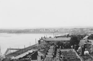
View of extensive Weymouth estuary and Alexander bridge 1920’s before damming
I’m starting with a potted history of this long lost estuary, but hopefully, if invited back, further articles will go on to share more of its colourful past and look towards its beautiful future.
Historically though, the Backwater was exactly that, a back water as opposed to the sea front. Weymouth, or to be more precise, what used to be Weymouth and Melcombe Regis, were two separate settlements that were divided by this estuary. (The name Weymouth: of course means mouth of the river Wey)


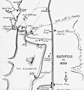
Radipole lake early 1900’s showing its extent pre damming
It was once a thriving estuary that was tidal as far as the village of Radipole, and not that long ago in the grand scheme of things.
Jetties were dotted around its shoreline, where nearby kilns churned out thousands of bricks to be loaded onto boats and ferried down to the port. Even these kilns hinted of smugglers and illicit sea trading according to Weymouth historian Debby Rose, some of whose ancestors owned one and had a reputation for such things. After all, where better to sail a craft upstream and moor far away from the bustling port and prying eyes of customs men.

Timber ponds lined its shores.
Further upstream, in Radipole, two mills turned and provided flour for the area.
Travelling back even further in time, many a discovery has been made that speaks of human activity along its shoreline, worked antlers, stone tools, ancient swords, coins, pottery and human remains to name but a few.
It is said that Radipole was once the Roman port of Clavinium, from which a road led to Durnovaria or modern day Dorchester.
(I shall duck down behind the proverbial parapet now and wait to hear from local historians on this much disputed statement!)
Humpty Dumpty field, now that is a name many older Weymouthians will recall fondly from their childhood days, was a medieval settlement on the shore as proven by an archaeological dig done in 1975 when an oven was uncovered. It’s also suggested that this village was constructed atop the old roman site.

View of archaeological dig in Humpty Dumpty field Radipole
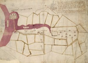
Come the 17th century and two bulwarks can be seen on an early 17th c enclosure map, they stood somewhere around the area where Alexander bridge now stands. These were presumably built to protect ships and people from marauding pirates or invaders because at that time Radipole’s St Anne’s church was the parish church for Melcombe Regis, (Weymouth folk headed for their redemption to Wyke Regis) Every Sunday the godly fearing townsfolk would have to treck upstream or uphill to their places of worship.
A passage from James Marwell in the Sherran Papers dated 1604 might just give us a clue as to why it was deemed necessary to fortify this channel of water.

‘Radipole Church is one mile and a half off[…]While the people of Melcombe Regis are absent at Radipole great danger and harm may arise by houses or ships taking fire or ships leaving moorings and damaging themselves on the new bridge.[…]Also there is great to houses and ships at such times from “the forrein Ennemy or by Rovers”’
So what changed all this?
Why isn’t it still an open tidal estuary with a variety of boats moored throughout its length, stunning shoreline walks complete with picnic spots to take in its views?
Basically it boiled down to man, money and that goddam awful stench!
Reclamation was necessary for the growth of Weymouth and Melcombe Regis, the latter being built on what was basically a mere sand spit. Once good old George III had waved his magic orb and turned our town into the holiday resort it has become today, man searched for land upon which they could erect more grand houses and create a resort any well-heeled person would clamour to visit.
Of course, the only way they could go was waterside and so it began, one scheme of reclamation after another and Weymouth’s estuary entrance and then further inland began to get smaller and smaller.
As for that goddam stench…that’s another story.
*********
are being supported by the
No Comments